Lower Bidwell Park is the portion of Bidwell Park that is west of Manzanita Avenue. It is perhaps most well known for multitudes of picnic sites (many of which are disabled persons accessible), swimming, running, and road biking along flat pathways.
Find updated information on trail, gate, and facility status and hours at the City of Chico.
Hiking & Walking
A hike through Lower Bidwell Park takes you through the mellow half of Chico’s famed Bidwell Park, with flat and level trails and a thick canopy of trees offering ample shade. Whenever you visit, you’ll enjoy diverse views throughout the year: in the fall, the park is full of vibrant oranges, reds, and yellows of changing foliage, while in the spring, it comes alive with seasonal wildflowers. With a start at the “Decide or Ride” compass, located adjacent to the One-Mile Recreation Area bike and pedestrian bridge, you’ll have the freedom to choose your own adventure through Lower Park. The paved path creates an accessible loop, while the unpaved trail will take you on an out-and-back journey.
Public bathrooms and water fountains are available in certain locations (by Sycamore Pool, in the Chico Creek Nature Center, and just across Manazita Avenue). Parking is available in convenient locations, and cars are comfortably few on pathways that allow them.
Key Info
Trail Difficulty: Easy
Trail Length & Type: Mileage varies between 1 and 5 miles
Best Used: Accessible year-round.
Dogs: Allowed on leash
Other Important Info: Wheelchair Accessible
Biking
Bikers can enjoy paved roads over flat terrain and easy, flat dirt trails throughout Lower Park. Bike trails are two miles or less and rated easy.
Swimming
Visitors can enjoy a dip in two swimming areas along Big Chico Creek. At One Mile Recreation Area, Sycamore Pool is a classic Chico summertime experience. The concrete basin fills with the naturally flowing waters of the creek. At Five Mile Recreation Area, stairway access provides easy opportunities to swim in untamed, yet still mild, waters of the creek.
Weekend and Holiday Road Closures
Peterson Memorial Way and South Park Drive between Caper Acres and Centennial Avenue are both closed to vehicles on weekend and holidays. Vehicular access is open from the Cypress Street entrance of Lower Bidwell Park to Caper Acres so visitors can access parking at One Mile, Sycamore Field, and Caper Acres.
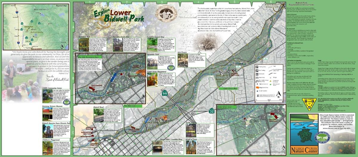
Map of Lower Park
Discover Lower Bidwell Park with this map. Get a free copy of the fold-out map, which includes the entirety of Bidwell Park, from the Chico Chamber of Commerce.

