
Situated above the city of Oroville, the North Table Mountain Ecological Reserve, more commonly known as simply Table Mountain, offers up a chance to hike through a truly unique natural area. Formed by ancient lava flows, the underlying basalt rock on the mesa holds water, resulting in spectacular annual wildflower blooms, stunning vernal pools, and dramatic but fleeting waterfalls.
Discover the best of Table Mountain by lacing up and exploring its many trails!
Jump to: Travel Tips │ Phantom Falls │ Beatson & Phantom Falls Loop │ Many Waterfalls Cross-County Loop
Get Your Lands Pass
When visiting Table Mountain, a CDFW Lands Pass must be carried by each visitor who is 16 years of age or older.
Visitors who are carrying a valid California hunting or fishing license in their name are exempt from this requirement. Lands passes may be purchased online, by phone at (800) 565‑1458, or in-person at locations wherever hunting and fishing licenses are sold. Lands passes cannot be substituted for Wildlife Area Hunting Passes, which are required for adult hunters on Type‑A and Type‑B wildlife areas.
Parking
Parking is available in a gravel lot on the west side of Cherokee Road. The lot has a limited number of spaces, so please plan to arrive early for the best opportunities to park.
No parking on the pavement is allowed along the paved portion of Cherokee Road, beginning approximately 3.0 miles north of the intersection of Oregon Gulch Road (large parking turnout near the crest of Cherokee Road) to Derrick Road (map). Vehicles parking on the shoulder must be parked completely off the pavement; violators are subject to tow.
Trip Tips for Responsible Travel
Make sure to help keep the reserve clean by following other Leave No Trace principles
Dogs must remain on-leash at all times
Trash cans and restrooms are available only at the parking lot, so plan accordingly, and be prepared pick up after yourself and pack out all trash
Stay on established trails, or travel on durable surfaces (like rocks or packed dirt) when off-trail travel is needed
Enjoy the views OF the wildflowers, not IN the wildflowers (don’t pick or walk on the wildflowers)
Respect the grazing cattle by staying at least 300 feet away from them at all times.
Drones are not allowed on the reserve without an appropriate film permit
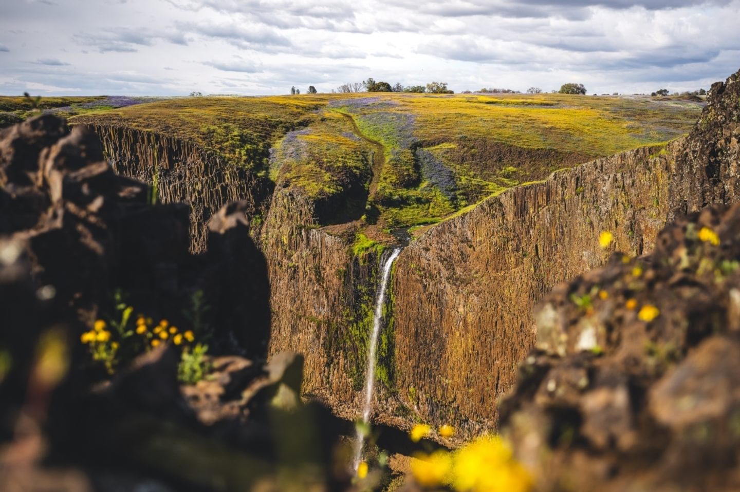
Phantom Falls
With trail updates by CDFW, the hike to Phantom Falls is now a fairly easy one. The waterfall runs during the rainy season, and in the spring, wildflowers carpet the North Table Mountain Ecological Reserve. There’s no shade, so make sure to wear a hat and sunscreen, and you’ll definitely want to go early to avoid the crowds during peak wildflower season.
From the parking area, follow the trail heading northwest — it’s a straight trail to Raving Falls. Start looking for a path leading downhill into the ravine. Depending on what season you go, Ravine Falls might be dried up but there is a clear signage for it when you get there. Then you will make your way up a mild incline and across the rolling hills towards Phantom Falls. Even if Phantom Falls is dry, you’ll know you’ve arrived because of the panoramic views of the canyon.
It’s easy to get lost on the cross-country trail, so we recommend downloading the free Avenza Maps app and the Phantom Falls map before your hike so that you can follow the GPS coordinates in real-time on your hike (you can also view a PDF version here).
Key Info
Trail Difficulty: Moderate
Trail Length & Type: 4.2 mile out-and-back
Best Used: November — April
Dogs: Allowed on leash
Trail Map: Phantom Falls Trail map
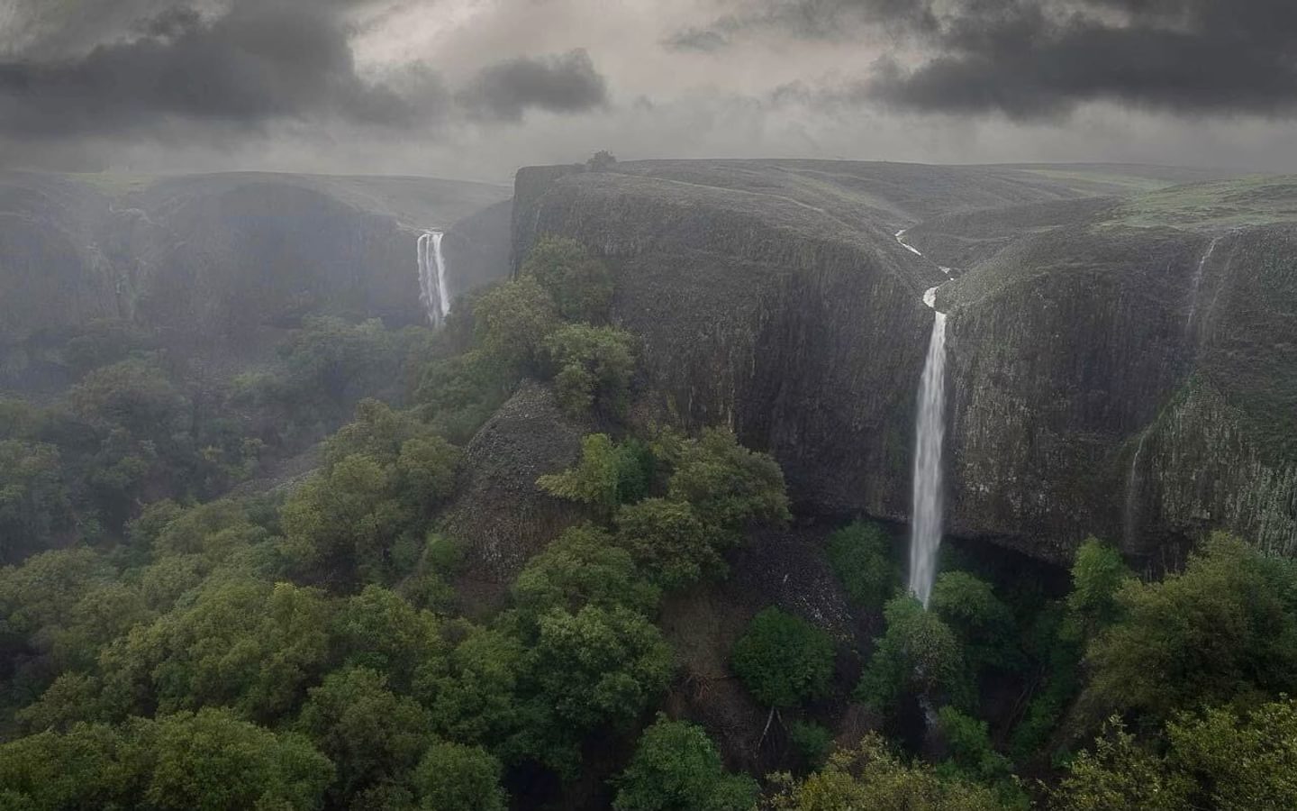
Beatson & Phantom Falls Loop
The Beatson and Phantom Falls Loop offers views of not only the aforementioned Phantom Falls, but also four other waterfalls (during the rainy season and early spring, that is). You’ll also get great wildflower views late February through April, and grazing cattle all-year round — just give them space (at least 300 feet), especially the occasional bull. Make sure to wear sturdy hiking boots, as part of the loop has no established trail and thus requires a little cross-country travel.
Key Info
Trail Difficulty: Moderate
Trail Length & Type: 6.7 mile loop
Best Used: November — April
Dogs: Allowed on leash
Trail Map: Phantom Falls Trail map (continue to Beatson Falls and then return to the Phantom Falls Loop trail)
Many Waterfalls Cross-Country Loop
The Many Waterfalls Cross-Country Loop is not the trail for anyone not willing to get wet and muddy…but they’ll be missing out on a seriously beautiful hike. Taking you around Table Mountain during the rainy season, this loop will have at least nine waterfalls, with 14 flowing within a few days of a major rainstorm and all of them dry during the summer. It’s a fleeting beauty worth seeing. Enjoy the most waterfalls January and February and then the wildflowers February through mid-April. It is easy to get lost on the cross-country trail, so we recommend downloading the free Avenza Maps app and the Many Waterfalls Loop trail map before your hike so that you can follow the GPS coordinates in real-time on your hike.
Key Info
Trail Difficulty: Difficult
Trail Length & Type: 11.3 mile loop
Best Used: November — April
Dogs: Allowed on leash
Trail Map: Many Waterfalls Cross-Country Loop map
Driving Directions
From Oroville, heading north on Hwy 70 and exit at Grand Ave. (Exit 48). Go east (right) on Grand Ave. for 1 mile. Left on Table Mountain Blvd for a tenth of a mile. Right on Cherokee Road 6.3 miles north to the reserve. Official access is through a small parking lot on the west side of Cherokee Road. From Chico, head south on Hwy 70 and exit at Grand Ave (Exit 48). Continue onto 4th St. and then turn Left onto Grand Ave., and then follow the rest of the directions from above.